The adjusted elevation of TBM 16 is
134.851-0.003 = 134.848 ft.
The adjustments for intermediate TBMs 17 and 18 are
made in a similar manner.
Reciprocal Leveling
This procedure is used for either differential or
trigonometric leveling when along sight across a wide
river, ravine, or similar obstacle must be made. This
long sight will be affected by curvature and refraction
and by any small error in aligning the line of sight with
the bubble axis. The alignment error can be minimized
by balancing the long sight and computing the
curvature. The atmospheric conditions will vary so
much over an open expanse that the refraction
correction will be quite erratic. Reciprocal leveling is
desired to minimize the effect of the atmosphere as well
as the line of sight and curvature corrections. To do this,
take the following actions:
1. In reciprocal leveling, balance the BSs and FSs
as carefully as possible before you reach the obstacle.
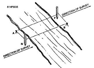
In figure 14-15, a TP, N, is selected close to the edge of
the obstruction so that it is visible from a proposed
instrument location, B, on the other side. A second rod
is held on the other side of the obstruction at F. Point F
should be selected so that the equivalent distances, AN
and FB, and AF and NB, are almost equal. The
instrument is setup at point A and leveled carefully. A
BS reading is taken on the N rod and an FS on the F rod.
These readings are repeated several times. The
instrument is moved to point B, set up, and carefully
leveled. The rods remain at their stations. Again, a BS
is taken on the N rod and an FS on the F rod, and
repeated several times. Since instrument leveling is
especially critical on reciprocal leveling, you need to
check the bubble before each reading and center it
carefully. If it is off-center a slight amount, the
procedure must be repeated. The difference in
elevation between N and F is computed from the
readings at A setup and from the readings at B setup
separately. Because of the errors in the long sight, the
two results will have slightly different values. Note,
however, that the long sight is an FS from A and a BS
from B. The true difference in elevation is the average
of both values, since the errors have opposite signs and
will cancel each other.
Figure 14-15.-Reciprocal leveling.
2. For more accuracy, make several long sight
readings for each short sight and average them. You
should use a target on the rod and reset it for each
reading. Average each series of long sights and
combine this average with corresponding short sights
for the computations.
3. Changes in atmospheric density and
temperature affect the refraction of a line of sight. The
longer the time interval is between reciprocal long
sights, the greater the chance of an atmospheric change
and a variation in the refraction value. For this reason,
you should keep the time lapse between the long sights
as short as possible.
4. An excellent method of avoiding the time lapse
problem is simultaneous-reciprocal observation. The
object is to read both long sight values at the same time.
This requires two instruments and two observers and
two rods and two rodmen. Some method of
communication or sequence of operations must be
agreed upon.
5. The note keeping for reciprocal leveling is
identical to differential leveling. Take a series of either
BS or FS readings on the far rod from one setup and
take only one sighting on the rear rod. Average the
series of readings, and use a single value to make the
elevation computations.
Profile Leveling
In surveying, a PROFILE is a vertical section of
the earth measured along a predetermined or fixed
line. In practice, profiles are a series of ground
elevations determined by differential leveling or
other methods that, when plotted along
14-15

