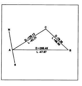
Figure 7-45.—Level net for use in answering question Q4.
Q4.
Q5.
Q6.
Refer to the level circuit ABCA shown in figure
7-45. What is (a) the error of closure in the
circuit, and (b) the corrected difference in
elevation (cycle I) for line AB?
What is the latitude of a 300-foot traverse line
running due east and west?
Assume that you are working with a traverse that
has a total length of 2,541.35 feet, an error of
closure in latitude of –1.73 feet, and an error of
closure in departure of +2.01 feet. What is the
ratio of error of closure?
Q7. Compute the bearing of traverse line AB when
the coordinates of station A and B are follows:
Station A: X = 627.42, Y= 326.87
Station B: X = 864.81, Y= 542.50
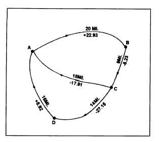
Q8. Refer to figure 7-46. What is the approximate
area contained within the traverse?
Figure 7-46.—Closed traverse for use with question Q8.
7-30