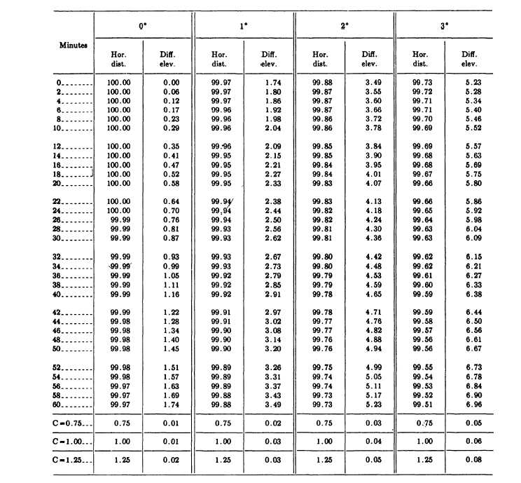
Figure 8-11.-Horizontal distances and elevations from stadia readings.
For the horizontal distance and elevation of point 1,
set a rod on the point, and train the lower stadia hair of
the transit telescope on a whole-foot mark on the rod so
that the center hair is near the 4.8 graduation. (This is a
common practice in stadia work that makes reading the
stadia interval easier.) Then read and record the stadia
interval (in this case 6.23 feet). Next, rotate the telescope
about the horizontal axis until the center hair is on the
4.8 rod graduation. Lock the vertical motion and read
and record the vertical angle (-3026’). Be sure to record
each vertical angle correctly as plus or minus. While you
are reading and recording the vertical angle, the rodman
can be moving to the next point. This will help speed up
the survey.
From the stadia interval and the vertical angle
reading, the horizontal distance (entered in the fifth
column of fig. 8-10) and the difference in elevation (in
the sixth column) are determined from a stadia reduction
table. Figure 8-11 shows the page from a stadia
reduction table that applies to the data for point 1 in
figure 8-10. For this point, the vertical angle is –3026’,
8-11