corners, particularly where the corner markers
themselves lack permanence. In timbered country,
blazes on trees on or adjacent to a boundary line are
most useful in reestablishing the line at a future date.
It is also advisable to state the names of abutting
property owners along the several sides of the tract
being described. Many metes-and-bounds
descriptions fail to include all of these particulars and
are frequently very difficult to retrace or locate in
relation to adjoining ownerships.
One of the reasons why the determination of
boundaries in the United States is often difficult is that
early surveyors often confined themselves to minimal
description; that is, to a bare statement of the metes
and bounds, courses and distances. Today, good
practice requires that a land surveyor include all
relevant information in his description.
In preparing the description of a property, the
surveyor should bear in mind that the description must
clearly identify the location of the property and must
give all necessary data from which the boundaries can
be reestablished at any future date. The written
description contains the greater part of the information
shown on the plan. Usually both a description and a
plan are prepared and, when the property is
transferred, are recorded according to the laws of the
county concerned. The metes-and-bounds description
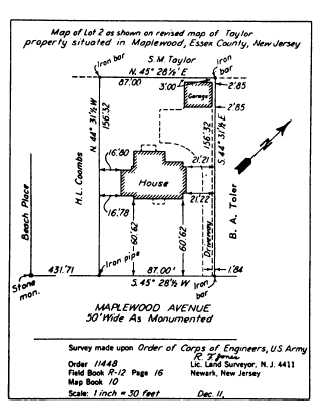
of the property shown in figure 10-34 is given below.
“All that certain tract or parcel of
land and premises, hereinafter particu-
larly described, situate, lying and being
in the Township of Maplewood in
the County of Essex and State of New
Jersey and constituting lot 2 shown on
the revised map of the Taylor property
in said township as filed in the Essex
County Hall of Records on March 18,
1944.
“Beginning at an iron pipe in the
northwesterly line of Maplewood Ave-
nue therein distant along same line four
hundred and thirty-one feet and sev-
enty-one-hundredths of a foot north-
easterly from a stone monument at the
northerly corner of Beach Place and
Maplewood Avenue; thence running
(1) North forty-four degrees thirty-one
and one-half minutes West along land
of. . .”
Another form of a lot description maybe presented as
follows:
“Beginning at the northeasterly
corner of the tract herein described;
said corner being the intersection of the
southerly line of Trenton Street and the
westerly line of Ives Street; thence run-
ning S6°29´54´´E bounded easterly by
said Ives Street, a distance of two hun-
dred and twenty-seven one hundredths
(200.27) feet to the northerly line of
Wickenden Street; thence turning an
interior angle of 89°59´16´´ and run-
ning S83°39´50´´W bonded southerly
by said Wickenden Street, a distance of
one hundred and no one-hundredths
(100.00) feet to a corner; thence turn-
ing an interior angle of. . . .”
You will notice that in the above example, interior
angles were added to the bearings of the boundary
lines. This will be another help in retracing lines.
Figure 10-34.—Lot plan by metes and bounds.
10-31