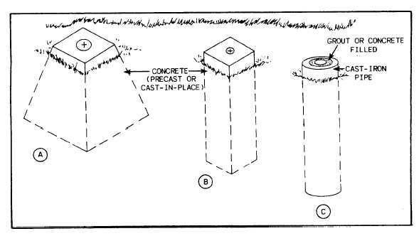
constructed in concrete. Figure 12-7 shows
common types of concrete monuments. The top
of the monument should have an area large
enough to include the required point and any
necessary reference data. The depth of the
monument should be sufficient to extend below
the frost line. If the depth of the frost line is
unknown, a minimum depth of 3 ft is generally
accepted. Other factors, such as soil condition and
stability of foundation, may also affect the depth
of the monuments. The area should be checked
out for soil stability to provide an adequate
foundation. A monument settles in the same
manner as any other structure if an adequate
foundation is not provided.
The exact location of the point on a monu-
ment may be marked by chiseling an X on the
surface or by drilling a hole with a star drill and
hammering in a lead filler or grouting in a length
of brass stock (often called a COPPER). When
grouting a copper, you should use neat cement
grout because a fluid grout would flow into and
fill the small space around the copper. If the point
can be placed at the same time as the monument
is being cast in place, the copper can be pushed
down into the surface of the monument before
the concrete begins to harden. If you are near an
armory, you may be able to obtain large,
expended brass shell casings. The primer end of
a shell casing makes an excellent survey point
marker when it is embedded in a concrete
monument.
With a little imagination and ingenuity, you
can easily design and construct adequate survey
monuments when they are required.
Identifying Points
A point is marked with the information
required to identify the point and with any other
relevant data. Temporary identification marks can
be made with keel. More permanent marks can
be made with paint. An even more permanent
mark consists of a metal plate set in concrete.
A. point that indicates a traverse station is
marked with the symbol or number of the station,
such as STA. B or STA. 21. A point on a
stationed traverse is marked with the particular
station, such as 2 + 87.08. Frequently, a point
will serve as a traverse station and a bench mark.
A bench mark is marked with an identifying
symbol and usually with the elevation. In marking
such an elevation, do not use a decimal point, as
in 317.22 ft. Instead, raise the figures that indicate
the fractional part and underline them; for
example, 3172Z ft.
Referencing Points
All control points should be tied in or
referenced. The ties or reference points are
Figure 12-7.-Common types of survey monuments.
12-8


