You know from the bearing of BC that, angle
S´BC measures 50°. The interior angle ABC is
The sum of the interior and exterior angles at
any traverse station or point equals the sum of
all the angles around that point, or 360°.
Therefore, the exterior angle at station B equals
360° minus the interior angle or
The process of measuring angles around a point
to obtain a check on their sum, which should
equal 360°00’, is sometimes referred to as
CLOSING THE HORIZON.
Converting Azimuths to Bearings
or Vice Versa
Suppose you want to convert an azimuth of
135° to the corresponding bearing. This azimuth
is greater than 90° but less than 180°; therefore,
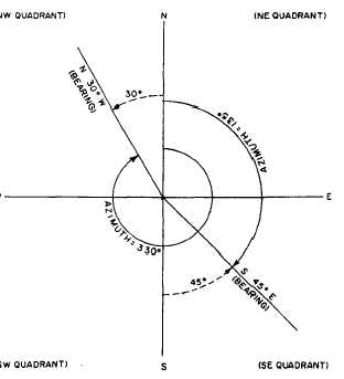
the line lies in the southeast quadrant. As shown
in figure 13-3, the bearing angles are always
measured from the north and south ends of
thereference meridian. (When solving any bearing
Figure 13-3.-Converting azimuths to corresponding bear-
ings or vice versa.
problem, draw a sketch to get a clear picture.) For
the azimuth, the horizontal direction is reckoned
clockwise from the meridian plane. It is measured
between either the north or the south end of the
reference meridian and the line in question. When
we talk about azimuth in this training manual,
however, you must understand that the azimuth
is referenced clockwise from the NORTH point
of the meridian. The numerical value of this 135°
azimuth angle is measured from the north.
Therefore, in this figure, the value of the bearing
is
The complete description of the bearing then is
S45°E.
For example, if you want to convert a bearing
of N30°W into an azimuth angle, you know that
the angle location must be in the northwest
quadrant. Then, draw an angle of 30° from the
north end of the reference meridian because you
measure azimuth angles clockwise from the north
end of the reference meridian. To compute this
azimuth angle, subtract 30° from 360°; the result
is 330°. Therefore, the bearing of N30°W is equal
to 330° azimuth angle.
ESTABLISHING DIRECTION BY
SURVEYOR’S COMPASS
The basic method of establishing direction of
a survey line or a point is with a surveyor’s
compass. (Notice that on most surveyor’s
compasses, the east and west indicators are in the
opposite positions from those of the east and west
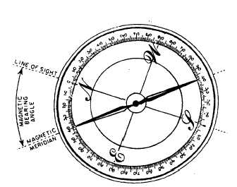
indicators on a map or chart.) In figure 13-4, an
Figure 13-4.-A magnetic compass reading corrected for
local attraction.
13-3


