of the draftsman, as well as the date of survey,
are to be included in the title block.
Maps developed as a basis for studies are so
varied in purpose that the above information may
be adequate for some but inadequate for others.
The Engineering Aid, when in doubt, should
consult the senior EA, the engineering officer, or
the operations officer as to the information
desired in the proposed map. The senior EA or
the chief of the field survey party is required
to know all these requirements before actual
fieldwork is started.
A map with too much information is as bad as
a map with too little information on it. It is not
surprising to find a map that is so crowded with
information and other details that it is hard to
comprehend. If this happens, draw the map to a
larger scale or reduce the information or details
on it. Then, provide separate notes or descriptions
for other information that will not fit well and
thus will cause the appearance of overcrowding.
Studying the features and quality of existing maps
developed by NAVFACENGCOM and civilian
architects and engineers (A & E) agencies will aid
you a great deal in your own map drawing.
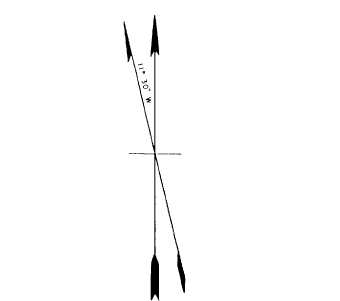
Orientation Symbol
Every map you draw has to have an ORIEN-
TATION SYMBOL (sometimes called meridian
arrows) on it. The symbol that represents
the direction of the meridian is indicated by
a needle or feathered arrow pointing north. It
must be drawn long enough that it could be
transferred accurately to any part of the map.
The FULL-HEAD ARROW represents the true
meridian; the HALF-HEAD ARROW, the mag-
netic meridian. If both are drawn, as shown in
figure 11-1, the angle between them must be
indicated. The general tendency is to draw the
symbol in an artistic way; however, the simple
design shown in figure 11-1 is adequate for most
purposes. If possible, the top of a map must
always be oriented north; however, the shape of
the mapped area or the most important features
of the project may alter this preference.
Kinds of Maps
Maps are classified according to purpose,
scale, or type. Maps classified according to
purpose include strategic, tactical, and artillery
maps; communications, utilities, or soil maps;
and maps pertaining to special studies. When
maps are classified according to scale, you have
large-scale, medium-scale, and small-scale. Some
Figure 11-1.-An orientation symbol or meridian arrows.
of the more common types, such as geographic,
planimetric, topographic, hydrographic, special-
purpose, and photomaps or mosaics, are briefly
described in the next several paragraphs.
GEOGRAPHIC MAPS.— A geographic map
is a map of a large area, such as that of a state
or country, that shows the location of towns,
counties, cities, rivers or streams, lakes, roads,
and principal civil boundaries, such as county and
state lines. Maps showing the general location of
the works of people, such as the Railroad Map
of the United States, the Irrigation Map of
Arizona, and the Panama Canal Zone Map, are
classified as geographical maps.
PLANIMETRIC MAPS.— These maps show
natural or man-made features in a horizontal
plane only. Relief in a measurable form is
omitted. A few examples of planimetric maps
are property, maps for city layout, site plan,
communications, route and distance, and isogonic
maps of the magnetic variation lines.
TOPOGRAPHIC MAPS.— Maps that depict
the natural and man-made features of the earth’s
surface in a measurable form, showing both
horizontal and vertical positions are called
topographical maps. Vertical positions, or relief,
are normally represented by contours. A precise
topographic map shows surface features so
perfectly that it can be used for making an exact
three-dimensional model of the area. Such a
model is called a RELIEF MAP. Your work in
11-10