familiar enough with field notes to preclude a com-
plete discussion of everything shown in these notes.
You should notice, however, that the stations are
entered in reverse order (bottom to top). In this manner
the data is presented as it appears in the field when you
are sighting ahead on the line. This same practice
applies to the sketch shown on the right-hand page of
the field notes.
For information about other situations involving
inaccessible points or the uses of external and middle
ordinate distance, spiral transitions, and other types of
horizontal curves, study books such as those men-
tioned at the beginning of this chapter.
VERTICAL CURVES
In addition to horizontal curves that go to the right
or left, roads also have vertical curves that go up or
down. Vertical curves at a crest or the top of a hill are
called summit curves, or oververticals. Vertical
curves at the bottom of a hill or dip are called sag
curves, or underverticals.
GRADES
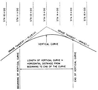
Vertical curves are used to connect stretches
of road that go up or down at a constant slope. These
lines of constant slope are called grade tangents
(fig. 11- 13). The rate of slope is called the gradient,
or simply the grade. (Do not confuse this use of the
term grade with other meanings, such as the design
Figure 11-13.—A vertical curve.
elevation of a finished surface at a given point or the
actual elevation of the existing ground at a given
point.) Grades that ascend in the direction of the
stationing are designated as plus; those that descend
in the direction of the stationing are designated as
minus. Grades are measured in terms of percent; that
is, the number of feet of rise or fall in a 100-foot
horizontal stretch of the road.
After the location of a road has been determined
and the necessary fieldwork has been obtained, the
engineer designs or fixes (sets) the grades. A number
of factors are considered, including the intended use
and importance of the road and the existing
topography. If a road is too steep, the comfort and
safety of the users and fuel consumption of the
vehicles will be adversely affected; therefore, the
design criteria will specify maximum grades.
Typical maximum grades are a 4-percent desired
maximum and a 6-percent absolute maximum for a
primary road. (The 6 percent means, as indicated
before, a 6-foot rise for each 100 feet ahead on the
road.) For a secondary road or a major street, the
maximum grades might be a 5-percent desired and an
8-percent absolute maximum; and for a tertiary road
or a secondary street, an 8-percent desired and a
10-percent (or perhaps a 12-percent) absolute
maximum. Conditions may sometimes demand that
grades or ramps, driveways, or short access streets go
as high as 20 percent. The engineer must also consider
minimum grades. A street with curb and gutter must
have enough fall so that the storm water will drain to
the inlets; 0.5 percent is a typical minimum grade for
curb and gutter (that is, 1/2 foot minimum fall for each
100 feet ahead). For roads with side ditches, the
desired minimum grade might be 1 percent; but since
ditches may slope at a grade different from the
pavement, a road may be designed with a zero-percent
grade. Zero-percent grades are not unusual,
particularly through plains or tidewater areas. Another
factor considered in designing the finished profile of
a road is the earthwork balance; that is, the grades
should be set so that all the soil cut off of the hills may
be economically hauled to fill in the low areas. In the
design of urban streets, the best use of the building
sites next to the street will generally be more important
than seeking an earthwork balance.
COMPUTING VERTICAL CURVES
As you have learned earlier, the horizontal curves
used in highway work are generally the arcs of circles.
But vertical curves are usually parabolic. The
11-12


