stadia arc. The striding level contains a long
bubble, and when attached, permits accurate
leveling of the line of sight. The bubble is mounted
on a metal tube with V-fittings on each end. The
fittings are placed astride the telescope and bear
on built-in polished brass rings on each side of
the center post. A spring clip on the level grips
a center pin on top of the telescope and keeps the
level from falling or being knocked off during
operation. A button on the side of the level
releases the clip for removing the level. For
checking and adjusting, the level is reversible. The
striding level normally is used to establish a
horizontal line of sight and to use the alidade as
a level. The stadia arc assembly consists of a
vertical arc mounted on the end of the left
trunnion and a vernier attached to the left bearing
by an arm. A level vial is attached to the upper
end of the arm; a tangent screw controls the
movement of the vial. Once adjusted, this vial
establishes a reference from which vertical angles
can be measured even if the plane table is not
exactly level. The stadia arc is a vertical scale
attached to the alidade. With the stadia arc, it is
possible to determine horizontal distances and
differences in elevation by the stadia method.
6. A new model telescopic alidade is the
self-leveling, optical-reading instrument. Instead
of the exterior arc and level bubble, a prism
system with a suspended element and enclosed
arcs is used. As long as the alidade base is leveled
to within one-half degree of horizontal, the
suspending element (or pendulum) will swing into
position. Then the vertical arc index that is
attached to it will assume a leveled position. The
scales are read directly through an optical train.
This combination permits faster operation. In
addition, there is no chance of forgetting to index
the arc bubble and introducing errors into the
readings.
Some of the auxiliary equipment used with a
plane table consists of a coated plastic or a paper
plane table sheet on which the map or sketch is
drawn, drawing materials (scribing tools for
coated plastic or pencils for the paper), scales for
plotting distances, triangles, waterproof table
covers, umbrella, and notebook. The plane table
sheet is attached to the board by flatheaded,
threaded studs that fit into recesses in the table
and do not obstruct the alidade’s movement.
instrument accessories used in connection with
field measurements.
FIELD TOOLS
If you are running a survey across rough
terrain, the essential equipment you will need are
various types of tools used for clearing the line;
that is, for cutting down brush and other natural
growth as necessary.
Surveying procedures usually permit the
bypassing of large trees. Occasionally, however,
it may be necessary to fell one of these. If heavy
equipment is working in the vicinity, an EO may
fell the tree with a bulldozer. The next best
method is by means of a power-driven chain saw.
In the absence of a chain saw, a one-man or
two-man crosscut saw may be available.
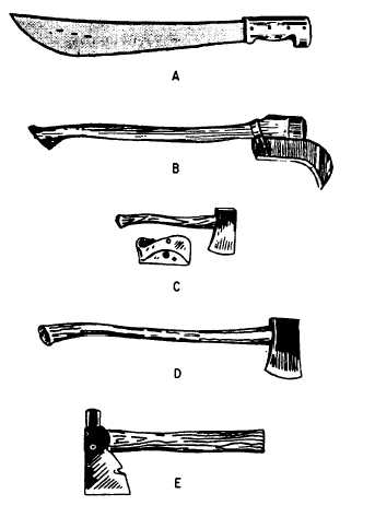
The machete and brush hook (fig. 11-32) are
used for clearing small saplings, bushes, vines, and
similar growth. Axes and hatchets (fig. 11-32) are
used for felling trees and also for marking trees
FIELD EQUIPMENT
The term field equipment, as used in this
training manual, includes all devices, tools, and
Figure 11-32.-(A) Machete; (B) Brush hook; (C) Single-bit
belt ax; (D) Single-bit ax; (E) Half hatchet.
11-35