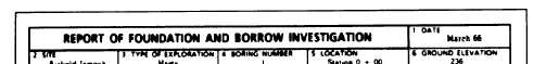
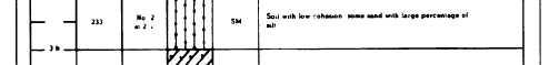
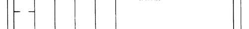
Figure 16-1.—Typical boring log.
The soil profile (fig. 16-2) is a graphical
The soil profile has many practical uses in the
representation of a vertical cross section from the
location, design, and construction of roads, airfields,
surface downward through the soil layers. It shows the
dams, and buildings. It greatly influences the location
location of test holes and of any ledge rock encountered,
of the finished grade line; these should, of course, be
located so as to take full advantage of the best soils
a profile of the natural ground to scale, field
available at the site. The profile also shows whether soils
identification of each soil type, thickness of each soil
to be excavated in the course of construction are suitable
stratum, profile of the water table, and profile of the
for use in embankments or whether you require borrow
finished grade line. Standard soil symbols should be
soils instead. It may show the existence of undesirable
used to indicate the various soil layers. The standard
soils, such as peat or other highly organic soils; it may
procedure is to add the proper color symbols
also show the existence of bedrock too close to the
representing the various soil types you discover.
surface. It aids in planning drainage facilities since these
16-6