3. RELIEF. Relief is the representation of the shape
and height of landforms and the characterization of the
surface of the earth.
The elevation of points and the relief of an area
affect the movement and deployment of units by
limiting the route of travel, their speed of movement,
and the ease or difficulty of attacking or defending an
area. Also relief affects observation, fields of fire,
cover, concealment, and the selection of key terrain
features.
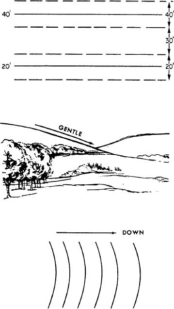
Figure 5-6.--Estimating elevations between contour lines.
Contour Lines
There are several ways of indicating elevation and
relief on maps. The most common way is by contour
lines. A CONTOUR LINE is a line representing an
imaginary line on the ground along which all points are
at the same elevation.
Contour lines indicate a vertical distance above
or below a datum plane. Starting at sea level,
normally the zero contour, each contour line
represents an elevation above sea level. The
vertical distance between adjacent contour lines is
known as the CONTOUR INTERVAL. The amount
of the contour interval is given in the marginal
information. On most maps, the contour lines are
printed in brown. Starting at zero elevation, every
fifth contour line is drawn with a heavier line.
These are known as INDEX CONTOURS.
Someplace along each index contour, the line is
broken and its elevation is given. The contour lines
falling between index contours are called
Figure 5-7.--Uniform, gentle slope.
INTERMEDIATE CONTOURS. They are drawn
with a finer line than the index contours and,
usually, do not have their elevations given.
crossed multiplied by the contour interval is the distance
above or below the starting value.
Using the contour lines on a map, you may
determine the elevation of any point as follows:
When the desired point is on a contour line, its
1. Find the contour interval of the map from the
elevation is that of the contour.
marginal information, and note both the amount and the
For a point between contours, most military needs
unit of measure.
are satisfied by estimating the elevation to an accuracy
2. Find the numbered contour line (or other given
of one half of the contour interval. All points less than
elevation) nearest the point for which the elevation is
one fourth of the distance between the lines are
being sought.
considered to be at an elevation of one half of the contour
3. Determine the direction of slope from the
interval above the lower line (fig. 5-6).
numbered contour line to the desired point.
To estimate the elevation of the top of an unmarked
4. Count the number of contour lines that must be
hill, add half of the contour interval to the elevation of
crossed to go from the numbered line to the desired point
and note the direction-up or down. The number of lines
the highest contour line around the hill.
5-10


