vertical
known
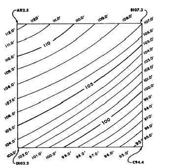
Figure 8-12.-Methods of indicating relief.
distance between adjacent contour lines is
as the contour interval. Starting at zero
elevation the topographer draws every fifth contour line
with a heavier line. These are known as index contours.
At some place along each index contour, the line is
broken and its elevation is given. The contour lines
falling between index contours are called intermediate
contours. They are drawn with a finer line than the
index contours and, usually, do not have their elevations
given. Examples of index contours and intermediate
contours are shown in figure 8-13.
GROUND POINT SYSTEMS
The essential data for showing relief by contour
lines consists of the elevation of a sufficient number of
ground points in the area. Methods of determining the
Figure 8-13.—Traverse with contour lines.
horizontal and vertical locations of these ground points
are called ground point systems. The systems most
frequently used are (1) tracing contours, (2) grids, (3)
control points, and (4) cross profiles. In practice,
combinations of these methods may be used in one
survey.
Tracing Contours
In the tracing contours system, the ground points
located are points on the actual contours. Points on a
given contour are plotted on the map, and the contour
line is drawn through the plotted points. The method
may be illustrated by the following simple example.
Refer again to the traverse shown in figure 8-13. In
this figure, assume that the traverse runs around the
perimeter of a small field. The elevations at comers A,
B, C, and D are as shown. Obviously the ground slopes
downward from AB toward DC and from AD toward
BC.
You want to locate contours at a contour interval of
1 fret; that is, you want to plot the 112-foot contour line,
the 110-contour line, the 110-foot contour line, and so
forth. In this example, we will assume that the required
order of precision is low, such as you may encounter in
a reconnaissance survey, and because of this you are
using a hand level.
You stand at station A with a hand level. The
elevation of this station is 112.5 feet. Assume that the
8-13


