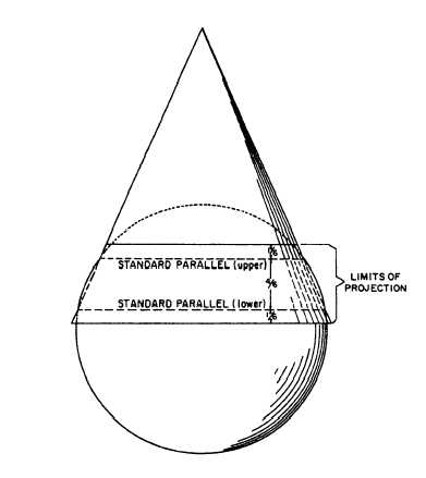
Figure 9-25.-Lambert conformal conic projection.
chart projection. A great circle is any line on the
earth’s surface (not necessarily a meridian or the
equator) that lies in a plane that passes through the
earth’s center. Any meridian lies in such a plane; so
does the equator. But any parallel other than the
equator lies in a plane that does not pass through the
earth’s center; therefore, no parallel other than the
equator is a great circle.
Now, 1 minute of arc measured along a great
circle is equal to 1 nautical mile (6076.115 ft) on the
ground. But 1 minute of arc measured along a small
circle amounts to less than 1 nautical mile on the
ground. Therefore, a minute of latitude always
represents a nautical mile on the ground, the reason
being that latitude is measured along a meridian and
every meridian is a great circle. A minute of longitude
at the equator represents a nautical mile on the ground
because, in this case, the longitude is measured along
the equator, the only parallel that is a great circle. But
a minute of longitude in any other latitude represents
less than a nautical mile on the ground; and the higher
the latitude, the greater the discrepancy.
LAMBERT CONFORMAL CONIC
PROJECTION
The Lambert conformal conic projection
attains such a near approach to both directional and
distance conformality as to justify its being called a
conformal projection. It is conic, rather than
polyconic, because only a single cone is used, as
shown in figure 9-25. Instead of being considered
tangent to the earth’s surface, however, the cone is
considered as penetrating the earth along one
standard parallel and emerging along another.
Direction is the same at any point on the map, and the
distance scale at a particular point is the same in all
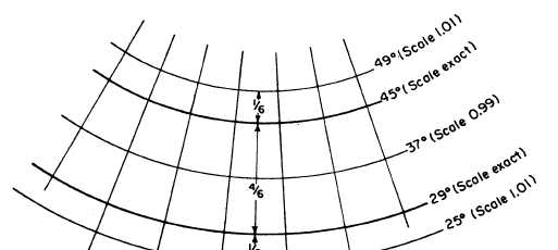
Figure 9-26.-distortion of the Lambert conformal conic projection with the standard parallels at 29 degrees and 45 degrees.
9-22