directions. However, the distance scale that applies to
the whole map is exact only at the standard parallels,
as shown in figure 9-26. Between the parallels the
scale is a little too small; beyond them, it is a little too
large. The discrepancy is small enough to be ignored
in work of ordinary precision or less. For work of
higher precision, there are correction factors that may
be applied.
The Lambert conformal conic projection is the
base for the state coordinate systems devised by the
Coast and Geodetic Survey for zones of limited north-
south dimension and indefinite east-west dimension.
For zones whose greater dimension is north-south, the
Coast and Geodetic Survey uses the transverse
Mercator projection.
Q1.
Q2.
Q3.
QUESTIONS
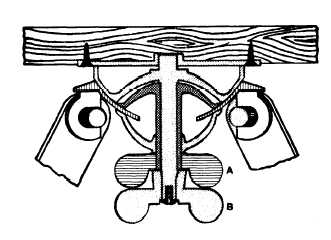
Which one of the wingnuts, labeled A and B, in
figure 9-27 permits a leveled plane table to be
rotated in azimuth?
Assume you are using three-point resection to
plot the location of point P and the triangle of
error is inside the main triangle formed by the
three known points. Where in relation to the
triangle of error is point P located?
What point-location method can you use to run
a traverse using a plane table?
9-23
Figure 9-27.-Cross section of a plane-table tripod head.
Q4.
Q5.
Q6.
Q7.
Compute the missing column entries for point 5
in figure 9-8.
Why is transverse Mercator projection the pre-
ferred projection method for use with the mili-
tary grid reference system ?
Refer to figure 9-14. What is the complete desig-
nation for the first full square east of meridian
168°W and south of the equator?
Measured along any meridian, what is the ap-
proximate distance in statute miles between
16°30’N latitude and 0°30f$ latitude ?