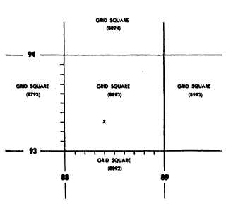
Figure 9-17.-Division of a grid square.
omitted; for example, the grid location of the bullion
depository at Fort Knox may be given as
16SES90999315. This means zone-row 16S, 100,000-
meter square ES, casting 9099, northing 9315.
Actually, the casting is 590,990 and the northing
4,193,150.
If four digits are given in a coordinate element, the
coordinates pin a point down to a particular 10-meter
square. Consider figure 9-17, for example. For the
point X, the two-digit coordinates 8893 would mean
that the point is located somewhere within the 1,000-
meter-grid square 8893. To pin the location down to
a particular 100-meter square within that square, you
would have to add another digit to each coordinate
element. The X lies four-tenths of 1,000 meters
between line 88 and line 89; therefore, the casting of
the 100-meter square is 884. By the same reasoning,
the northing is 933. The coordinate for the 100-meter
square is therefore 884933. To pin the point down to
a particular 10-meter square, you should add another
pair of digits, these being determined by scale
measurement on the map. It follows from all this that
the coordinates previously given for the bullion at Fort
Knox (909993 15) locate this building with reference
to a particular lo-meter square.
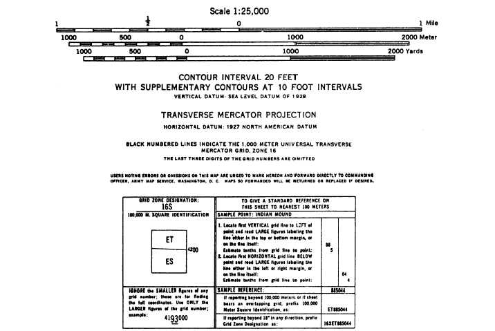
Figures 9-18 and 9-19 show the marginal
information usually given on a UTM grid military
map. Note the reference box, which gives the grid
zone-row and 100,000-meter-square designation. The
Figure 9-18.-Marginal information on a military map (1).
9-17