Table 8-1.-Recommended Contour Intervals–Topographic Map
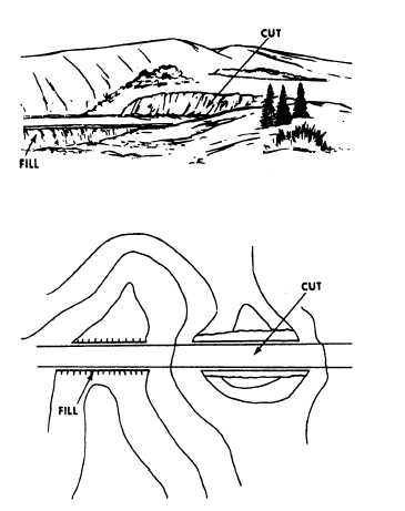
Cuts and fills are man-made features that result
when the bed of a road or railroad is graded or leveled
off by cutting through high areas and filling in low areas
along the right-of-way (fig. 8-28).
A vertical or near vertical slope is a cliff. As
described previously, when the slope of an inclined
surface increases, the contour lines become closer
together. In the case of a cliff, the contour lines can
actually join, as shown in figure 8-29. Notice the tick
marks shown in this figure. These tick marks always
point downgrade.
MAP SCALES AND CONTOUR INTERVALS
A topographic
intermediate scale,
following criteria:
Large scale:
Intermediate scale:
Small scale:
The designated
map is called
or small scale
either large scale,
by the use of the
1 inch= 100 feet or less
any scale from 1 inch= 100 feet
to 1 inch= 1,000 feet
1 inch= 1,000 feet or more.
contour interval varies with the
purpose and scale of the map and the character of the
terrain. Table 8-1 shows the recommended contour
intervals that you may use to prepare a topographic
map.
Figure 8-28.-Contour (cut and fill).
8-20