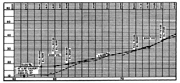
Figure 3-4.-Road profile.
curves), which will be discussed shortly. The grade lines
may be level or sloped. If the lines slope upward, the
grade is positive; if downward, the grade is negative.
The slopes are in reference to the direction of increasing
stations. The amount of slope is lettered above the grade
line and is usually indicated as the percent of slope. In
figure 3-4, the slope from station 66 + 00 to 71 + 00 is
+2.00 percent. This means the center-line grade rises 2
feet in 100 feet horizontal distance. If the slope is -1.50
percent, the grade would fall 1.50 feet in 100 feet
horizontal distance.
At vertical curves, the straight lines are tangents that
intersect at a point called the point of vertical
intersection (PVI). This point is comparable to the PI
of horizontal curves.
Vertical Curves
If the road is to offer safe, comfortable driving
conditions, the PVI should not break sharply. The length
of the curve depends upon the steepness of the
intersecting grades. In most cases, a vertical curve is
symmetrical in that its length is the same on both sides
of the PVI. Unlike the length of a horizontal curve, the
length of a vertical curve is the horizontal distance from
beginning to end of the curve, rather than the distance
along the curve. The station on which the curve begins
and ends is called the point of vertical curvature (PVC)
and point of vertical tangency (PVT), respectively.
Unlike horizontal curves, vertical curves are parabolic;
they have no constant radius. Therefore, the curves are
plotted, usually in 50-foot lengths, by computing the
offsets from the two tangents. A vertical curve at the
crest or top of a hill is called a summit curve, or
oververtical; one at the bottom of a hill or a dip is called
a sag curve, or undervertical.
Drawing the Grade Lines
You should use the same horizontal and vertical
scale to draw the grade line as to draw the profile. ‘Ibis
allows the amount of cut or fill for a particular point to
be measured. If the grade line is higher than the profile,
fill is required; if lower, cut is required.
The profile and grade-line drawings also show the
relative locations of drainage structures, such as box
culverts and pipe. You use only the vertical scale to draw
these structures. You can plot the heights of the
structures accurately, using the vertical scale. However,
because of the exaggerated difference between the
vertical and horizontal scales, you cannot draw the
width of the structures to scale. Therefore, you should
draw the width of the structures just wide enough to
indicate the type of structure. You should show a box
culvert as a high, narrow rectangle and a round pipe as
a high, narrow ellipse.
ROAD DIMENSIONS
The type of dimensioning used for road plans is a
variation of the standard dimensioning. In road
dimensioning, numerical values for elevations, cuts,
fills, and stations are considered dimensions also. Most
road dimensions appear on the profile and grade-line
3-5