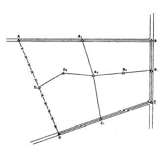
Figure 9-1.—Primary traverse and secondary traverse.
edge of the blade. A more in-depth discussion of
orienting the plane table will follow later in this chap-
ter.
Next, carefully measure the vertical distance be-
tween the horizontal line of sight through the telescope
and the ground level at D1. Let’s say this distance is
4.5 feet. This means that, whenever you sight on a rod,
you will line up the horizontal cross hair with the
4.5-foot graduation on the rod.
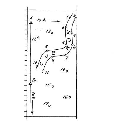
Figure 9-2 is a sketch of the detail points that we
are plotting. Point D1 and point A in this figure corre-
spond to the same points in figure 9-1. Assuming that
your alidade is equipped with a Beaman stadia arc
(some alidades are not), plot point 1 of figure 9-2 in
the following way. With the edge of the alidade blade
exactly on D1 on the paper, train the telescope on a rod
held on point 1, and line up the horizontal cross hair
with the 4.5-foot mark on the rod.
You read a rod intercept of 6.23 feet. This means
the slope distance is 623.0 feet. On the H-scale of the
Beaman arc, you read three-tenths of one percent; you
will have to estimate this less than one-percent read-
ing. The horizontal distance, then, is three-tenths of
one-percent less than the slope distance, or
623.0 feet - (623.0 x 0.003 feet) = 623.0-1.87.
This rounds off to the nearest foot at 621 feet. Add
a focal distance of 1 foot, and the result is 622 feet.
Figure 9-2.-Sketch of topographic detail points.
On the V-scale, you read 44. You know that the
value you use is the difference between what you read
and 50. In this case, it is 6. Therefore, the difference
in elevation is 6 percent of the slope distance, or
623.0 x 0.06 = 37.4 feet.
Then, the elevation of point 1 is the elevation of
D1 minus the difference in elevation, or
532.4 -37.4 = 495.0 feet.
As you know, the difference in elevation was
subtracted because the vertical angle was negative.
Finally, with the edge of your alidade blade still
on D] and your telescope still trained on point 1, you
can draw a light line and measure off 622 feet from D1
along the line to locate point 1. At that distance along
the line, mark and label the point and write in the
elevation. Many topographers use the decimal point in
the elevation to mark the point.
ORIENTATION METHODS
As you learned from the above example, plotting
of detail points cannot begin until the plane-table
9-2