tops are driven so that the top of the hub is set
at the required grade elevation.
7. GUARD STAKES are used to identify and
protect hubs. The face of the stake is marked
with station identification and is placed so
that the stake faces the hub it identifies.
Sometimes more than one guard stake will be
used to protect a hub.
8. OFFSET STAKES may be additional
stakes that are offset a known distance from other
stakes that will likely be disturbed during
construction. The offset stake is marked with the
same information as the stake it offsets, and it
is also marked to show the offset distance. Often,
stakes will themselves be offset a known distance
from their true location. This eliminates the
requirement for additional stakes.
CENTER-LINE LAYOUT.— The first major
step in highway construction is usually the rough
grading; that is, the earthmoving that is required
to bring the surface up to, or down to, the
approximate elevation prescribed for the
subgrade. The SUBGRADE is the surface of
natural soil, or the place where the pavement will
be laid. The subgrade elevation, therefore, equals
grade (finished surface) elevation minus the
thickness of the pavement.
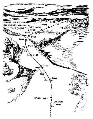
In rough grading, the equipment operators are
usually guided by grade stakes that are set along
the center line by the transit-tape survey party at
center-line stations. The center-line stations
(stakes) are usually set at intervals of 100 ft or
more on straight-line stretches and intervals of
50 ft or less on roads with horizontal and vertical
curvatures. On a small-radius, street-corner
curve, a center-line hub or stake might be set
at the center of the circle of which the curve
is a part. This is done so the construction
crew may outline the curve by swinging the
radius with the tape. Reference stakes or hubs
are also set on one or both sides of the center
line to permit reestablishment of the center line
at any time.
Each center-line stake is marked with the
vertical depth of cut or fill required to bring the
surface to grade elevation. The surveyor must
indicate the station markings and the cut and fill
directions on stakes. Let’s look at the stakes on
the center line of the road-building job. The
starting point is the first station in the survey;
Figure 14-32.-Station markings.
this station is numbered 0 + 00. The next station
is normally 100 ft farther and is marked 1 + 00;
the third station is another 100 ft farther and is
marked 2 + 00; and so on. On sharp curves on
rough ground, the stakes may be closer together.
(See fig. 14-32.) Generally, the station markings
face the starting point. The mark ~, which is
also on the side facing the starting point, is
used to indicate that the stake is a center-line
stake.
A cut is designated by the letter C, and the
fill is indicated by the letter F. Numerals follow
the letters to indicate the amount that the ground
should be cut or filled. The symbol C– 13 indicates
that the existing ground should be cut 1.5 ft, as
measured from the reference mark. During
rough grading, the cut and fill are generally
carried just up to the nearest half foot; exact grade
elevations are later marked with hubs (blue tops).
The mark Y is called a crowfoot. The apex of
the V indicates the direction of the required
change in elevation; so a cut is indicated by Y ,
and a fill is indicated by fi . In some cases,
surveyors mark the grade stake only with a
negative or a positive number and the crowfoot,
indicating the cut or fill.
14-35